The first American locomotive at Castle Point in Hoboken, New Jersey, c. 18261869: The ceremony for the driving of the golden spike at Promontory Summit, Utah on May 10, 1869; completion of the First Transcontinental Railroad. At center left, Samuel S. Montague, Central Pacific Railroad, shakes hands with Grenville M. Dodge, Union Pacific Railroad (center right).
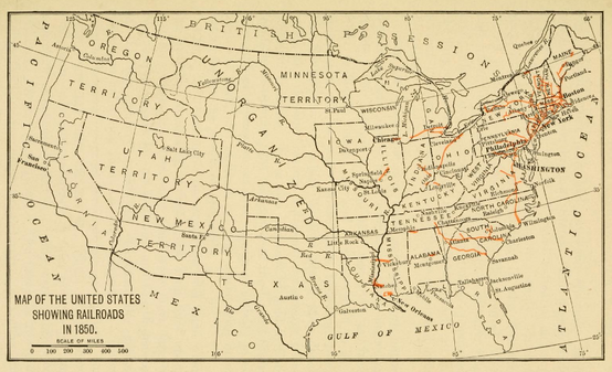
1850 map showing all the canals, railroads, telegraph lines and principal stage routes, drawn by Henry A. Burr, topographer to the Post Office Dept. Washington, D.C.; Author: J. Disturnell. ( Disturnell's New Map of the United States and Canada - NARA - 78117081)1852 Andrews Railroad Map of the United States - Geographicus - UnitedStates-andrews-1852; description: A rare and attractive wall sized railroad map of the United States issued in 1852 for Israel de Wolf Andrew’s report for the Treasury Department. Depicts from the Great Lakes south to the Gulf of Mexico, and from the states of Iowa, Missouri, Arkansas and Louisiana eastward to the Atlantic ... Essentially an updated version of McLellen’s map of 1850. Drawn and engraved under the direction of the editor of the “American Railroad Journal”.1856: Ensign, Bridgman & Fannings rail road map of the United States, showing the depots & stations (4584053944)
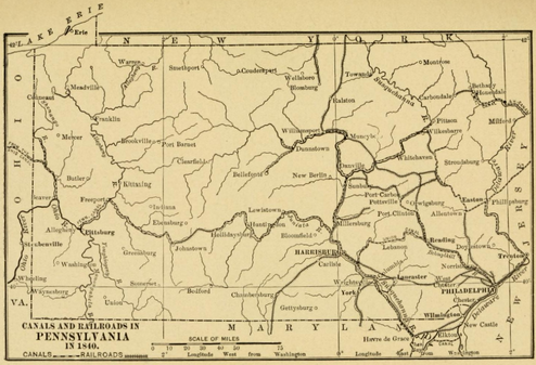
1860: History of transportation in the United States before 1860 (published 1917) (14574497328)Railroad of Confederacy-18611863 Map from "The Appeal to Arms, 1861-1863 (published 1907) of "means of transportation" available during the Civil War. (Image is juxtaposed pages from book scan, thus the missing middle portion of the map at the binding)
Map of the route of the First Transcontinental Railroad. Crossing to the Western United States to/from California. Built in the 1860s, and opening in 1869. Central Pacific (red line) Union Pacific (blue line) Western Pacific (green line)Profile of the Pacific Railroad from Council Bluffs/Omaha to San Francisco. Harper's Weekly December 7, 18671869 Railroad map of the United States to accompany the "Commercial travellers guide book" (NYPL b15829349-1952948)
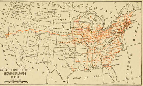
1870 Railroad Map "Close of the Civil War"(From: 'The History of the last Quarter-Century in the United States, 1870-1895 ... With ... illustrations' (11298291644)1873 Colton's Railroad and Commercial Map of the United States and Canada Page 11873 Colton's Railroad and Commercial Map of the United States and Canada - NARA - 86744253 (page 2)1877 Peel Atlas pg76-77 Railroad map of the United States PN2019 21865-8
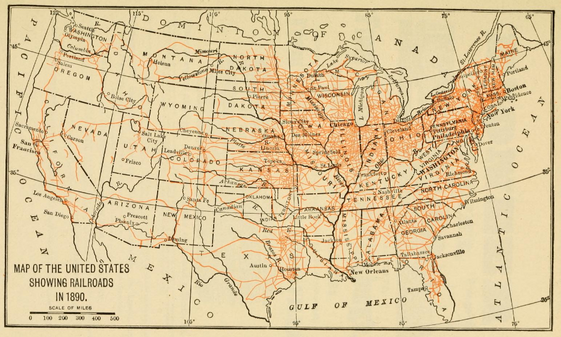
1890L American railway transportation (published 1908) (14572826500)1883: New Official Railroad map of the United States and Canada - DPLA - c7a911d967987d386dc73ac839640637US Transcontinental Railroads 1887


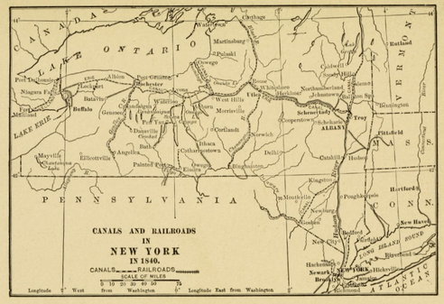
![1850 from History of transportation in the United States before 1860 (published 1917) (14760797742)]](https://upload.wikimedia.org/wikipedia/commons/thumb/2/27/History_of_transportation_in_the_United_States_before_1860_%281917%29_%2814760797742%29.jpg/330px-History_of_transportation_in_the_United_States_before_1860_%281917%29_%2814760797742%29.jpg)

_(14757946611).jpg)
![1850 from History of transportation in the United States before 1860 (published 1917) (14760797742)]](/wiki/File:History_of_transportation_in_the_United_States_before_1860_(1917)_(14760797742).jpg)
_(14574497328).jpg)


_(14784116252).jpg)
_(14804330853).jpg)


.jpg)


.jpg)
.jpg)
.jpg)
.jpg)


.jpg)
.jpg)
_(14573598059).jpg)


