U.S. railroads historical maps: Difference between revisions
No edit summary |
|||
| (3 intermediate revisions by the same user not shown) | |||
| Line 1: | Line 1: | ||
[[File:FWPNW026HobokenNJSA0266.jpg|right|thumb|The first American locomotive at Castle Point in Hoboken, New Jersey, c. 1826]] | |||
[[File:East_west_shaking_hands_by_russell.jpg|thumb|1869: The ceremony for the driving of the golden spike at Promontory Summit, Utah on May 10, 1869; completion of the First Transcontinental Railroad. At center left, Samuel S. Montague, Central Pacific Railroad, shakes hands with Grenville M. Dodge, Union Pacific Railroad (center right).]] | |||
== Railroad mileage history == | == Railroad mileage history == | ||
(adapted from [https://en.wikipedia.org/wiki/History_of_rail_transportation_in_the_United_States | (adapted from [https://en.wikipedia.org/wiki/History_of_rail_transportation_in_the_United_States History of rail transportation in the United States (wikipedia))] | ||
{| class="wikitable sortable" style="text-align:center" | {| class="wikitable sortable" style="text-align:center" | ||
| Line 78: | Line 80: | ||
|} | |} | ||
== Maps - similar maps showing growth | == Maps - similar maps showing growth over time == | ||
See [[commons:Category:Rail_transport_maps_of_the_United_States| Rail transport maps of the United States - Wikimedia Commons]] | |||
'''1840, 1850, 1860''' | |||
<gallery mode="packed-overlay" heights="300px"> | |||
History_of_transportation_in_the_United_States_before_1860_(1917)_(14757946611).jpg|1840 History of transportation in the United States before 1860 (published 1917) (14757946611) | |||
File:History of transportation in the United States before 1860 (1917) (14760797742).jpg|<nowiki>1850 from History of transportation in the United States before 1860 (published 1917) (14760797742)]</nowiki> | |||
History_of_transportation_in_the_United_States_before_1860_(1917)_(14574497328).jpg|1860: History of transportation in the United States before 1860 (published 1917) (14574497328) | |||
</gallery> | |||
'''1840, 1850. 1870, 1880, 1890''' | |||
see https://archive.org/details/americanrailwayt1908john/page/17/mode/1up?view=theater | |||
<gallery mode="packed-overlay" heights="225px"> | |||
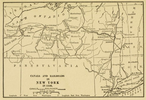
File:American Railway Transportation p-017 Canals and Railroad New York 1840.png|1840 Canals and Railroads | File:American Railway Transportation p-017 Canals and Railroad New York 1840.png|1840 Canals and Railroads | ||
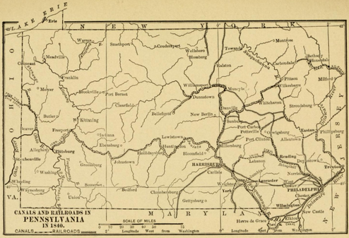
File:American Railway Transportation p-019 Canals and Railroad Pennsylvania1840.png|1840 Railroads | File:American Railway Transportation p-019 Canals and Railroad Pennsylvania1840.png|1840 Railroads | ||
| Line 87: | Line 100: | ||
'''1850, 1916''' | '''1850, 1916''' | ||
<gallery mode="packed-overlay" heights=" | <gallery mode="packed-overlay" heights="250px"> | ||
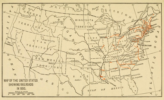
File:The story of corn and the westward migration (1916) (14784116252).jpg|1850 railroad map from "The story of corn and the westward migration" (published 1916) (14784116252) | File:The story of corn and the westward migration (1916) (14784116252).jpg|1850 railroad map from "The story of corn and the westward migration" (published 1916) (14784116252) | ||
File:The story of corn and the westward migration (1916) (14804330853).jpg|1916 railroad map from "The story of corn and the westward migration" (published 1916) (14804330853) | File:The story of corn and the westward migration (1916) (14804330853).jpg|1916 railroad map from "The story of corn and the westward migration" (published 1916) (14804330853) | ||
| Line 93: | Line 106: | ||
== Maps by decade == | == Maps by decade == | ||
=== 1830s === | === 1830s === | ||
Latest revision as of 20:42, 16 May 2024


Railroad mileage history[edit | edit source]
(adapted from History of rail transportation in the United States (wikipedia))
| Railroad Active Mileage by Region | |||||||||||||||||
| Region | 1830 | 1840 | 1850 | 1860 | 1870 | 1880 | 1890 | ||||||||||
|---|---|---|---|---|---|---|---|---|---|---|---|---|---|---|---|---|---|
| New England | 30 | 513 | 2,596 | 3,644 | 4,273 | 5,888 | 6,718 | ||||||||||
| East | 1,484 | 3,740 | 11,927 | 18,292 | 28,155 | 40,826 | |||||||||||
| South | 10 | 737 | 2,082 | 7,908 | 10,610 | 14,458 | 27,833 | ||||||||||
| Midwest | 46 | 4,951 | 11,031 | 22,213 | 35,580 | ||||||||||||
| South Central (LA, AR, OK/Indian Territory) |
21 | 107 | 250 | 331 | 1,621 | 5,154 | |||||||||||
| West (including TX, CO, KS) |
239 | 4,578 | 15,466 | 47,451 | |||||||||||||
| TOTAL U.S. | 40 | 2,755 | 8,571 | 28,920 | 49,168 | 87,801 | 163,562 | ||||||||||
Maps - similar maps showing growth over time[edit | edit source]
See Rail transport maps of the United States - Wikimedia Commons
1840, 1850, 1860
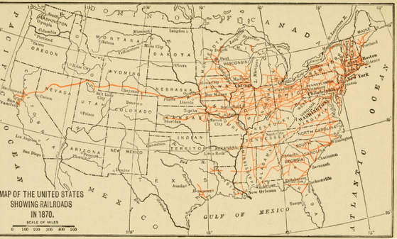
1840, 1850. 1870, 1880, 1890 see https://archive.org/details/americanrailwayt1908john/page/17/mode/1up?view=theater
1850, 1916
Maps by decade[edit | edit source]
1830s[edit | edit source]

1840s[edit | edit source]
1850s[edit | edit source]


[edit | edit source]


1860s[edit | edit source]


1870s[edit | edit source]


1880s[edit | edit source]


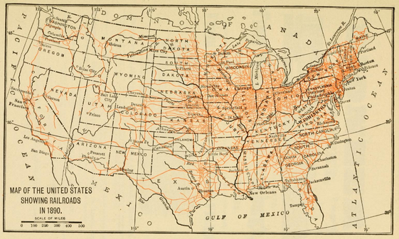
1890s[edit | edit source]

1900s[edit | edit source]


1920s[edit | edit source]

1950s[edit | edit source]
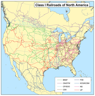
2000s[edit | edit source]
Travel time by rail[edit | edit source]
Map shows travel time in days from New York City to three regions across the U.S.

National Highways[edit | edit source]
> section to be placed in separate page


![1850 from History of transportation in the United States before 1860 (published 1917) (14760797742)]](https://upload.wikimedia.org/wikipedia/commons/thumb/2/27/History_of_transportation_in_the_United_States_before_1860_%281917%29_%2814760797742%29.jpg/330px-History_of_transportation_in_the_United_States_before_1860_%281917%29_%2814760797742%29.jpg)
