From A+ Club Lesson Planner & Study Guide
Preparation for the state of Virginian SOL ("Standards of Learning") History test: Native American, Colonial & American Revolution periods
Native American regions of North America [ edit | edit source ]
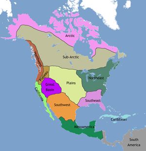
Major Regions of Native Americans in North America [ edit | edit source ] A map of North America showing the regions of Native American cultures. (wikipedia) Native American Language groups [ edit | edit source ] Language families of Indigenous peoples in North America: shown across present-day Canada, Greenland, the United States, and northern Mexico
BIG IDEAS
Native American tribes and language groups were divided into these basic geographic regions
these maps will not be on the Virginia SOL
however, they provide a good overview of distribution Native American ethnic, language and tribal groups
Native American tribal groups [ edit | edit source ] prior to European colonization
this map excludes Canada Eastern tribes & general language groups, pre-colonial era
BIG IDEAS
at the time of English and French colonization, Native American tribes occupied all areas of European colonization
and were aligned by language and ethnic groups
the English and French made treaties and/or fought with various tribes
which re-aligned Native American tribal arrangements
the French generally allied with Algonquin tribes and confederations
the English generally allied with Iroquois tribes and confederations
Colonial America & territorial expansion [ edit | edit source ]
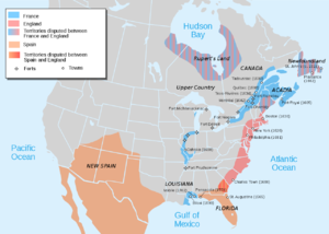
1702 European colonial possessions [ edit | edit source ] European colonial possessions as of 1702, just before Queen Anne's War. After the war, Britain took the disputed territories of Newfoundland, Nova Scotia and Maine (wikipedia)
BIG IDEAS
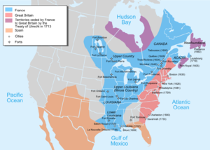
1748 European colonial possessions [ edit | edit source ] Map showing French possessions in North America just before the French-Indian War (1754)
BIG IDEAS
red = British colonies in red, including 13 American
striped red = British territory in Canada ceded (surrendered) by France to Britain in 1713
blue = French territory, called "New France"
orange = Spanish territory, which includes Florida and parts of modern Southwest US (an area that belonged to Mexico after Mexican independence from Spain)
the red (British) and blue (French) territories are separated by the Appalachian Mountains
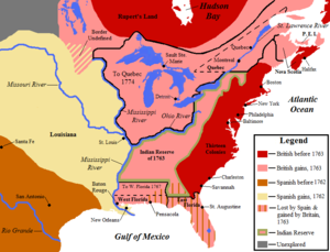
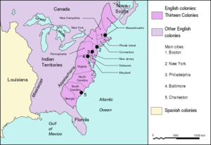
1762-1783 European colonial possessions [ edit | edit source ] European colonies in North American following the realignment of territories after the French-Indian War (1754-1763) and before the end of the American Revolution (1783) 1775 European colonial possessions [ edit | edit source ] Territories of the 13 English colonies, British-controlled "Indian Territories," and Spanish Louisiana, just before the American Revolution (1775)
BIG IDEAS
after the French-Indian War (1754-1763), the lands that had belonged to France became British
Canada
all lands east of the Mississippi River
France gave control of Louisiana to Spain
= lands west of the Mississippi River
English King George prohibited colonies from moving west of the Appalachian Mountains
he reserved that land for Native Americans ("Indian Territories")
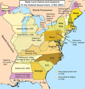
US possessions after the American Revolution [ edit | edit source ] Territories of the United States after Independence (1783), as well as British Canada and Spanish Louisiana (wikipedia)
BIG IDEAS
Britain ceded (surrendered) the "Indian Territory" to the United States after the American Revolution
so the US, now an independent country
owned all lands from the 13 former colonies along the East coast
to the Mississippi River
Spain maintained control of "Louisiana"
Britain kept Canada
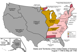
1790: early United States territories and states [ edit | edit source ] Organization of the United States, along with designated "territories" (areas that belonged to the US but were not yet independent states) (wikipedia)
BIG IDEAS
this map shows the organization of the United States upon adoption of the US Constitution in 1789
Virginia, Georgia and Massachusetts would later yield territory for other new states
