Geography fun facts and oddities
Geography fun facts & oddities
- collection of geography facts, oddities and extremes
- see also:
- Geography bee
- Geography vocabulary
- page organization t.b.d.
Physical geography fun facts[edit | edit source]
- Pitcaren Islands in Polynesia, are the least populated political entity in the world (67 residents)
- Vatican City, for example, has 825 residents
- Rio de la Plata is the widest river in the world (max width: 140 mi)
- the Rio de la Plata is considered a river, estuary, gulf or "marginal sea"
- it is fed by the Uruguay and Parana rivers at Punta Gorda ("fat point"
Physical geography oddities[edit | edit source]
Earthquakes[edit | edit source]

- 5-largest recorded earthquakes by magnitude:
- [9.4-9.5 1960 Valdivia earthquake, Chile]
- [9.2 1964 Alaska earthquake (wiki)]
- [9.1-9.3 2004 Indonesian earthquake (wiki)]
- [9.1 2011 Dhoku, Japan earthquake & tsunami (wiki)]
- [9.1-9.3 1730 Valparaiso, Chile earthquake (wiki)]
- see Tsunami section below for the 2004 Indian Ocean earthquake and tsunami
- 2011 Virginia earthquake
click EXPAND for details & video from top of the Washington Monument
Mountains[edit | edit source]

- Kirkjufell, Iceland
- a mountain formed of volcanic rock, but not itself a volcano
- during Ice Age was a "nunatak" = a landform protruding above glaciers
- it's unique spiraling forms were shaped by glaciers
- known for it serene waters which reflect the mountain and beautiful seasonal waterfalls (thus the name)
- was location for two seasons of "Game of Thrones" series
https://en.wikipedia.org/wiki/Kirkjufell
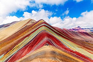
- Vinicunca, Peru
- located in southern Peru, two hours from Cusco
- 17,100 ft, not the highest mountain in the region
- notable for its multi-colored soil content
- its 7 colored strips consist variously of red and white clay, quartzose, sandstone, calcium carbonate and iron ore, among others
- it was covered by an ice cap until the 1990s
- as the ice melted, its unique, colored stripes were revealed
Volcanos[edit | edit source]
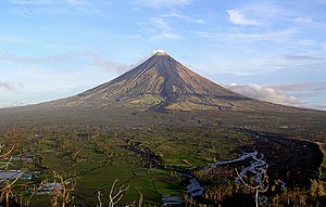
- Mt. Mayon, Philippines
- a stratovolcano that has a near-perfectly symmetric, or "perfect", cone
- = the most active volcano in the Philippines
- traditionally worshipped
- see https://en.wikipedia.org/wiki/Mayon

- Cueva de los Verdes ("the cave of Verdes")
- world's longest "lava tube" was created 3,000 years ago by the eruption of Monte Corona, Canary Islands
- lava tubes are formed when a lava stream cools and solidifies at the top, while lava below continues to flow, leaving a cave after full draining.
- the cave is 3.7 miles long on land and extends another 0.93 miles under water
- see Cueva de los Verdes (wikipedia)
- April's Fool volcano prank
- on April 1, 1974, pranksters climbed atop the dormant 3002 ft high volcano, Mt. Edgecumbe, near Sitka, Alaska
- a helicopter had dropped off old tires, kerosene, smoke bombs and rags, which the pranksters lit and threw into the crater
- a Coast Guard helicopter was dispatched to observe the eruption and instead saw a man standing by spray-painted show reading, "APRIL FOOL."
- see https://www.iflscience.com/environment/the-greatest-april-fools-day-prank-of-all-time-took-four-years-to-plan-and-involved-a-volcano/ Greatest April Fools Day Prank of All Time (iflscience.com)]
Rocks[edit | edit source]
Famous rocks[edit | edit source]
- Devil's Tower

- click EXPAND for details on Devil's Tower
- Independence Rock

- famous for unique formation and 19th century graffiti
- click EXPAND for details and more images of Independence Rock
- Pompy's Tower" (Pompey's Pillar National Monument)
- famous for inscription by William Clark from 1806
- click EXPAND for details and image of Pompey's Pillar
- Three Sisters or Three Sisters Islands
- click EXPAND for image, details and info on & legends behind the name of the rocks:
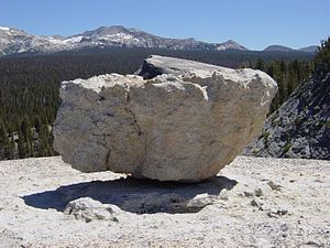
Glacial erratic rocks[edit | edit source]

- rocks that are moved to one place from another by glaciers
- and that are dissimilar (not like) the rocks where they are found
- Madison Boulder
- 83 ft long, 23 ft high and 37 feet wide
- the largest "glacial erratic" rock in North America
- one of the largest in the world
- it is of granite, while there is no other granite nearby
- thereby, we can know it was moved to that location by glaciers
click EXPAND for more images of glacial erratic rocks
see
- https://www.nhstateparks.org/visit/state-parks/madison-boulder-natural-area
- https://en.wikipedia.org/wiki/Glacial_erratic
Sinkholes[edit | edit source]

- sinkholes are holes or caves in the ground caused by erosion or a collapse of a lower, below-ground surface, usually because of water drainage
- sinkholes may also be caused by a drainage of water, such as a water table decline
- sinkholes are most common where limestone, sandstone, salt beds, or gypsum are prevalent
- Thor's Well
- a sinkhole on the coast of Cape Perpetua, Oregon, that drains at high tides
- Golly Hole in Alabama is considered the largest sinkhole in the US.
Click EXPAND for image and details on Golly Hole
- For more on sinkholes:
Tsunamis[edit | edit source]
- series of large waves caused by earthquakes, volcanic eruptions, landslides, glacier breaks, or meteorites
- also known as "tidal waves," although tsunamis are not tides
- see File:NOAA Tsunami Animation-2016.webm for tsunami animation
- or here [NOAA Tsunami channel] or [NOAA Model Animations]
- Lituya Bay, Alaska, 1957
- a narrow inlet, earthquake-induced tsunami waves reached 1,720 feet high
- see [1958 Lituya Bay, Alaska earthquake and megatsunami was the highest recorded Tsunami (wiki)]
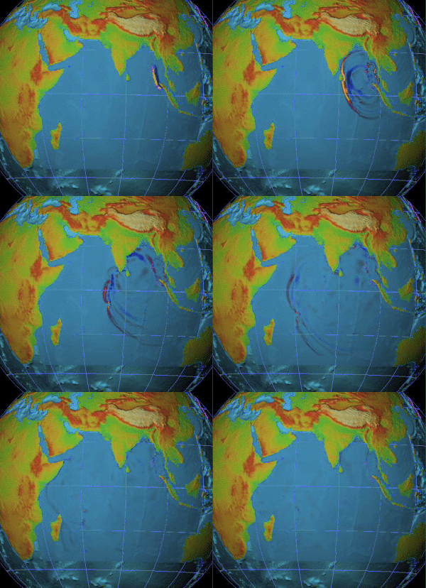
- 2004 Indian Ocean earthquake and tsunami
- 9.1 magnitude earthquake caused a 900-mile fault line between the Indian and Burnma tectonic plates
- as a result of the shift, the ocean floor rose upwards 10 feet, trigging up to 100-foot high tsunamis that spread across the entire Indian Ocean
- occurred on Dec 26, 2004, so is also known as the "Christmas" or "Boxing Day" earthquake and tsunami
click on EXPAND for more on the 2004 Indian Ocean earthquake and tsunami
Name origins (etymology) and unusual or odd names[edit | edit source]
- etymology is the study of the origin of words
Country names[edit | edit source]
- Literal Meanings of Country Names map
- a credit card travel service in Australia created a world map showing the "literal translation" of names of every country
- the original website is a sales site here: [https://finty.com/au/research/world-map-literal-translation-country-names/ (finty.com)]
- downloads for the world map and separate continents can be found at the bottom of that page
- here for the [direct link to the world map (finty.com)]
- here for articles on the map [Mapped: The Literal Translation of Every Country’s Name (VisualCapitalist.com)] or https://www.lonelyplanet.com/articles/map-literal-translation-country-names This map shows you the literal translation of country names (LonelyPlanet.com
- here [a web-based spreadsheet with details of the word origins (etymology)] from the makers of the map
America[edit | edit source]

- America is named for the Italian explorer and map-maker Amerigo Vespucci
- Vespucci was the first European explorer to recognize that the lands Christopher Columbus discovered were distinct regions from Asia
Click EXPAND for more on Vespucci and the Waldseemüller map which labeled part of the "new world" as "America"
Central America[edit | edit source]
- Yucatan
- Yucatan peninsula was named by the Spanish
- theories of the origins of the name
- when the Spanish arrived there, they asked the local Maya then name of the place and when the Maya replied that they didn't understand them, the Spanish thought that was the name of the place
click EXPAND for more details
Atlantic & Caribbean[edit | edit source]
- Antilles
- Canary Islands
- from the word "canine" for dogs that lived on the island
- Caribbean
- named for the Carib people that occupied southern portion of the Caribbean Sea
- the Taino people were the original inhabitants of the region, including the Bahamas
- Madeira
- Atlantic island 350 miles west of Morocco
- "madeira" means wood, as the islands had old-growth trees that the Portuguese used for ship building
click EXPAND for more on Madeira
British Islands[edit | edit source]
- Llanfairpwllgwyngyllgogerychwyrndrobwllllantysiliogogogoch
- original name of the Welsh village
changed its name in the 1860s from the shorter Llanfairpwllgwyngyll to increase its publicity. At 58 letters, it has the longest place name in the UK
Europe[edit | edit source]
Greenland & Iceland[edit | edit source]
Mid East[edit | edit source]
- Levant
- "the Levant" is a region consisting of the eastern coast of the Mediterranean Sea
- "levant" = French for "rising" or "risen"
- "levant" is the past participle (past tense verb used as an adjective) of the verb "lever" (to rise)
- = a reference to the sun rising from the eastern shores of the Mediterranean
Indus, India, Indonesia[edit | edit source]
- Indus is the name for the river that gives the name for India
- the Indus River is in Pakistan
- "indus" = indo-european word for "river
- "India" therefore is the "land of the River"
- "Indonesia" therefore "islands of India"
United States[edit | edit source]
- Accident, MD
- early settlement in western Maryland
- a competing survey of property "by accident" made a claim of the other's property
- people from Accident call themselves, "Accidentals"
- source: [Pictory History of Accident, Maryland, (WHILBR)]
- Lake Chargoggagoggmanchauggagoggchaubunagungamaugg
- located in Webster MA, anglicized spelling of original Native American name
- Telluride, Co
- named for the mineral "tellurium"
- located amidst the largest concentration of 14,000 ft mountains in the U.S.
- the apocryphal origin is that, due to the treacherous mountains, miners warned those who wanted to strike gold there, "To Hell You Ride!"
Political geography fun facts[edit | edit source]
- countries that have no capital
- countries with multiple capitals and/or official seats of government
- some countries have official capitals
- others have an official capital and another city that serves as a prominent "seat" of the government
click EXPAND for a few countries with multiple capitals:
- Freaky little places:
- Andorra
- Faroe Islands
Political geography oddities[edit | edit source]
Enclaves & exclaves[edit | edit source]
- see: https://en.wikipedia.org/wiki/Enclave_and_exclave
- enclave = a country or territory that is entirely surrounded by another country or territory
- "enclave" is derived from the Latin inclavare for "to close with a key," meaning one property that is entirely surrounded by another property
- nation state enclaves:
- click on EXPAND to see list of nation state enclaves:
- click EXPAND for a list of semi-exclaves:
- exclave = a territory or part of a country that is separated from the main country or territory and surrounded by one other country
- click EXPAND for a list of exclaves:
- semi-exclave = territory or part of a country that is separated from the main country or territory and surrounded by another country and a large body of water
- click EXPAND for a list of semi-exclaves:
- click EXPAND for a list of U.S. semi-exclaves:
- some places that are both enclaves and exclaves
- not independent countries, but part of one country that are surrounded by another
- click EXPAND to see a list of some places that are both ENCLAVES & EXCLAVES
Landlocked countries[edit | edit source]
- = countries that have no coastal borders
- click EXPAND to see a list of some prominent landlocked countries:
- Double Landlocked countries
- = landlocked countries surrounded by landlocked countries
- click EXPAND to see a list of the only two double-landlocked countries:
Physical geography extremes[edit | edit source]
Highest, lowest extremes[edit | edit source]
- the deepest spot on earth is 7,169.3 ft lower than Mt. Everest is high
- Lowest spot on surface of the earth
- underwater:
- Mariana Trench
- underwater:

- located in the South Pacific Ocean, deepest landform on earth
- 1,580 mi long, 43 mi wide, max. depth 36,201 ft
- click EXPAND for more on the Mariana Trench and other trenches
- lowest point on the land surface:
- the Dead Sea (Israel, Palestine & Jordan), 1419 ft below sea level
- 2nd lowest point on earth: Turfan Depression (China), 505 ft. below sea level
- this 2nd lowest point excludes other areas in the Dead Sea
- 3rd lowest point on earth: Lake Assal (Djibouti, part of the Afar Depression), 502 ft below sea level
- lowest point in US: Death Valley, 282 ft below sea level
- 2nd lowest point in US: Bombay Beach (California, along the Salton Sea, 226 ft below sea level
- click EXPAND for more on the Salton Sea
- continent with the "highest lowest point": Europe
- the Caspian Depression, location of the Caspian Sea is 92 ft below sea level
- the lowest point in Europe is in the coastal area, Zuidplaspolder, in the Netherlands, which is 23 ft below sea level
- continent with the "highest lowest point": Europe
- deepest cave: Krubera Cave (Georgia - the nation): 7,188 ft deep
- highest mountain on earth: Mt Everest: 29,031.7 ft
- highest mountain outside of the Himalaya-Karakoram range: Mt. Tirich Mir (Pakistan), in the Hindu Kush
- highest mountain outside of Asia: Mt. Aconcagua (Argentina) 22,835 ft
- highest volcano: Mt. Ojos del Salado (Argentina & Chile), 22,615 ft
- tallest mountain from its base: Mt. Mauna Kea, Hawaii, has combined elevation of 33,480 from its base on the ocean floor
- lake
- highest lake: a water-filled crater on Mt. Ojos del Salado (Argentina & Chile), 22,615 ft
- highest "navigable" lake: Lake Titicaca (Bolivia & Peru), 12,507 ft
Political geography extremes[edit | edit source]
Largest & smallest nations, Highest & lowest populations[edit | edit source]
- click EXPAND for the answers
Africa
- largest country in Africa by territory:
- second & third largest countries in Africa by territory:
- smallest country in mainland Africa:
- smallest smallest country in Africa, including islands:
highest population in Africa:
2nd highest population in Africa:
lowest population in mainland Africa:
lowest population in Africa among independent nations (territories excluded) and including island states:
lowest population in Africa, including island states and semi-independent territories:
second lowest population in Africa, including island states and territories:
Asia
Australia
- Australia is the largest and the smallest country in Australia
- Australia is the only country to entirely occupy a continent
Europe
- largest countries in Europe by territory
- smallest countries in Europe by territory
- 1
- 2
- 3
- Liechtenstein: 62 sq miles
- Liechtenstein has one of the highest per capital GDPs in the world
- largest countries in Europe by population
- Smallest countries in Europe by population
Directional extremes (north, south, east, west)[edit | edit source]
United States
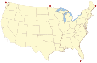
- easternmost point in continental U.S.: Sail Rock, Lubec, Maine
- northernmost state in the continental U.S.: Minnesota
- northernmost point in the continental U.S.: Northwest Angle, Minnesota, known as "The Angle"
- Click EXPAND to read more about the Northwest Angle:
Economic Extremes[edit | edit source]
- richest country by overall GDP
- richest country by per capita GDP
- poorest country by overall GDP
- poorest country by per capital GDP
- most industrialized country
- most agriculture-based country (least industrialized)
- most
Demographic Extremes[edit | edit source]
- the only Hindu-dominant island in Indonesia
- Bali
- most homogenous country
- most diverse country
- most languages
- most dialects
Regional extremes
Resources & websites[edit | edit source]
Geography jokes[edit | edit source]
U.S. states names[edit | edit source]
- What did Tennessee?
- The same thing as Arkansas
- How did Florida?
- She died of Missouri
- What did Delaware?
- She wore a New Jersey"
- What's the newest state?
- Not sure, but Alaska!
- How did Wiscon-sin?
- He stole a Nebrask-y
Europe[edit | edit source]
- I had a cousin named Lorraine. And another named Alsace.
- They never did get along.
- Cry me a river
- Sorry, Crimea is a peninsula, not a river!


