(10 intermediate revisions by the same user not shown)
Line 9:
Line 9:
* page organization t.b.d.
* page organization t.b.d.
== Physical geography fun facts ==
= Physical geography fun facts =
* Pitcaren Islands in Polynesia, are the least populated political entity in the world (67 residents)
* Pitcaren Islands in Polynesia, are the least populated political entity in the world (67 residents)
** Vatican City, for example, has 825 residents
** Vatican City, for example, has 825 residents
* Rio de la Plata is the widest river in the world (max width: 140 mi)
* Rio de la Plata is the widest river in the world (max width: 140 mi)
** the Rio de la Plata is considered a river, estuary, gulf or "marginal sea"
** the Rio de la Plata is considered a river, estuary, gulf or "marginal sea"
** it is fed by the Uruguay and Parana rivers at Punta Gorda ("fat point"
** it is fed by the Uruguay and Parana rivers at Punta Gorda ("fat point")
=== Ice Age ocean level ===
[[File:Global sea levels during the last Ice Age.jpg|thumb|Global sea level during the Last Glacial Period]]
=== Ice Age geography ===
=== Doggerland ===
[[File:Global sea levels during the last Ice Age.jpg|thumb|Global sea levels during the last Ice Age]]
==== Doggerland ====
== Physical geography oddities ==
= Physical geography oddities =
=== Caves ===
== Caves ==
[[File:Lanzarote 5 Luc Viatour.jpg|thumb|Lanzarote 5 Luc Viatour|alt=Lanzarote 5 Luc Viatour.jpg|World's longest "lava tube" in Cueva de los Verdes (wikipedia)]]
[[File:Lanzarote 5 Luc Viatour.jpg|thumb|Lanzarote 5 Luc Viatour|alt=Lanzarote 5 Luc Viatour.jpg|World's longest "lava tube" in Cueva de los Verdes (wikipedia)]]
* '''Cueva de los Verdes ("the cave of Verdes")'''
* '''Cueva de los Verdes ("the cave of Verdes")'''
Line 38:
Line 40:
*** [https://partner.sciencenorway.no/cathedral-fram-centre/natures-cathedral-people-have-gathered-in-this-cave-for-at-least-10000-years/2071325 Nature's cathedral: People have gathered in this cave for at least 10,000 years (sciencenorway.no)]
*** [https://partner.sciencenorway.no/cathedral-fram-centre/natures-cathedral-people-have-gathered-in-this-cave-for-at-least-10000-years/2071325 Nature's cathedral: People have gathered in this cave for at least 10,000 years (sciencenorway.no)]
An ancient desert lake on the eastern slope of the Sierra Nevadas that has no outflow and thus is highly salinated
* limestone columns, called "tufa towers," rise above the lake surface
* Mono Lake has two prominent islands, Negit Island, notable for its dark, lava origin, and Paoha Island, which was formed only in the 17th century by a series of volcanic eruptions.
[[File:View of Islands, Lake Cobbosseecontee, Me (67039).jpg|thumb|View of Islands, Lake Cobbosseecontee, Me (67039) Cobbosseecontee is a natural lake in the Winthrop Lakes Region, which has natural and man-made lakes along the Androscoggin River watershed region]]
[[File:MonmouthME NorthMonmouthMills.jpg|thumb|TexTech Industries manufacturers tennis ball felt in North Monmouth, Maine, using power from a dam that turned Wilson Stream into [[https://www.maine.gov/ifw/docs/lake-survey-maps/kennebec/wilson_pond.pdf Wilson Pond (1940 Maine government survey]]]]
=== Mill ponds ===
When small lakes or ponds are formed by dams built on a stream or river and used to power mills, the highest land points will become no longer hills above the stream but islands, as the water rises around them.
=== Porthmadog, Wales, United Kingdom ===
Recovered lowland from an estuary that was blocked off from the sea
Porthmadog presents an inverted lake, whereby the islands, which formerly protruded above the water surface became hills when the lake was drained.
* see https://en.wikipedia.org/wiki/Porthmadog
== Lakes ==
==== Recursive islands and lakes ====
[[File:1 taal volcano crater lake 2011.jpg|thumb|Taal Volcano crater lake 2011 (wikipedia) is a lake inside an island inside a lake]]
* = a lake or island inside an island or lake
** see https://en.wikipedia.org/wiki/Recursive_islands_and_lakes
* '''Vulcan Point''' in the Philippines has an island inside a lake inside of an island inside a lake
== Mountains ==
* Kirkjufell, Iceland
* Kirkjufell, Iceland
** a mountain formed of volcanic rock, but not itself a volcano
** a mountain formed of volcanic rock, but not itself a volcano
Line 143:
Line 173:
</gallery>
</gallery>
=== Rocks ===
== Rocks ==
=== Famous U.S. rocks ===
==== Famous U.S. rocks ====
===== Devil's Tower =====
===== Devil's Tower =====
* a butte formation in Wyoming that abruptly juts out of the landscape 1,267 ft high
* a butte formation in Wyoming that abruptly juts out of the landscape 1,267 ft high
Line 190:
Line 221:
</gallery>
</gallery>
==== Famous rocks around the world ====
=== Famous rocks around the world ===
[[File:Qasr al Farid.JPG|thumb|Qaṣr Al-Farīd (Arabic: قَصْر ٱلْفَرِيْد), meaning ‘the Lonely Castle’ is largest tomb at the archaeological site]]
[[File:Qasr al Farid.JPG|thumb|Qaṣr Al-Farīd (Arabic: قَصْر ٱلْفَرِيْد), meaning ‘the Lonely Castle’ is largest tomb at the archaeological site]]
===== Qaṣr Al-Farīd=====
===== Qaṣr Al-Farīd=====
Line 206:
Line 237:
[[File:White-desert-egypt.jpg|600px|center|Panorama of the White Desert of Egypt|alt=Panorama of the White Desert in Egypt]]
[[File:White-desert-egypt.jpg|600px|center|Panorama of the White Desert of Egypt|alt=Panorama of the White Desert in Egypt]]
==== Glacial erratic rocks ====
=== Glacial erratic rocks ===
* rocks that are moved to one place from another by glaciers
* rocks that are moved to one place from another by glaciers
** and that are dissimilar (not like) the rocks where they are found
** and that are dissimilar (not like) the rocks where they are found
Line 229:
Line 260:
</gallery>
</gallery>
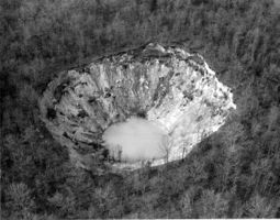
=== Sinkholes ===
=== Sailing Stones ===
* [[File:Racetrack_Playa_(Pirate_Scott).jpg|thumb|Sailing stone in Racetrack Playa, Death Valley, California (wikipedia)]]also called "sliding rocks" or "walking rocks"
* the phenomenon usually occurs in dry lake beds
* "sailing stones" move locations when water around them freezes, then starts melting, leaving mud and ice fragments that allow for the rock to slides on the slippery ground when propelled by the wind or gravity.
* sliding rocks leave a trail, so when they stop their transit, they leave a trail that makes it look as if the rock had moved itself along the desert floor.
[[File:Racetrack_Playa_in_Death_Valley_National_Park.jpg|thumb|A sailing stone in Racetrack Playa (wikipedia)]]
=== Racetrack Playa ===
* probably the most famous sailing stones are found at "Racetrack Playa" in Death Valley, California.
* the ground there is dried clay and while limited, there is enough precipitation, 3-inches per year, for water to collect in the basin and freeze, creating the conditions for the rocks to seemingly move by themselves, leavning a track behind them.
== Sinkholes ==
* sinkholes are holes or caves in the ground caused by erosion or a collapse of a lower, below-ground surface, usually because of water drainage
* sinkholes are holes or caves in the ground caused by erosion or a collapse of a lower, below-ground surface, usually because of water drainage
** sinkholes may also be caused by a drainage of water, such as a water table decline
** sinkholes may also be caused by a drainage of water, such as a water table decline
Line 248:
Line 294:
</gallery>
</gallery>
=== Tsunamis ===
== Tsunamis ==
* series of large waves caused by earthquakes, volcanic eruptions, landslides, glacier breaks, or meteorites
* series of large waves caused by earthquakes, volcanic eruptions, landslides, glacier breaks, or meteorites
** also known as "tidal waves," although tsunamis are not tides
** also known as "tidal waves," although tsunamis are not tides
** see [[File:NOAA Tsunami Animation-2016.webm||right|thumb|NOAA Tsunami Animation-2016]] for tsunami animation
** see [[File:NOAA Tsunami Animation-2016.webm||right|thumb|NOAA Tsunami Animation-2016]] for tsunami animation
*** or here [[https://www.youtube.com/playlist?list=PL3BDBAAAA7D4EB2DA NOAA Tsunami channel]] or [[https://nctr.pmel.noaa.gov/animate.html#most NOAA Model Animations]]
*** or here [[https://www.youtube.com/playlist?list=PL3BDBAAAA7D4EB2DA NOAA Tsunami channel]] or [[https://nctr.pmel.noaa.gov/animate.html#most NOAA Model Animations]]
*
* '''Lituya Bay, Alaska, 1957'''
* '''Lituya Bay, Alaska, 1957'''
** a narrow inlet, earthquake-induced tsunami waves reached 1,720 feet high
** a narrow inlet, earthquake-induced tsunami waves reached 1,720 feet high
** see [[https://en.wikipedia.org/wiki/1958_Lituya_Bay,_Alaska_earthquake_and_megatsunami 1958 Lituya Bay, Alaska earthquake and megatsunami was the highest recorded Tsunami (wiki)]]
** see [<nowiki/>[[wikipedia:1958_Lituya_Bay,_Alaska_earthquake_and_megatsunami|1958 Lituya Bay, Alaska earthquake and megatsunami was the highest recorded Tsunami (wiki)]]]
* '''2004 Indian Ocean earthquake and tsunami'''
* '''2004 Indian Ocean earthquake and tsunami'''
** 9.1 magnitude earthquake caused a 900-mile fault line between the Indian and Burnma tectonic plates
** 9.1 magnitude earthquake caused a 900-mile fault line between the Indian and Burnma tectonic plates
Line 285:
Line 330:
</div>
</div>
=== Volcanos ===
== Volcanos ==
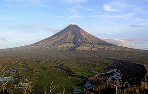
* '''Mt. Mayon, Philippines'''
* '''Mt. Mayon, Philippines'''
** a stratovolcano that has a near-perfectly symmetric, or "perfect", cone
** a stratovolcano that has a near-perfectly symmetric, or "perfect", cone
Line 329:
Line 373:
== Physical geography extremes ==
= Physical geography extremes =
=== Highest, lowest extremes ===
== Highest, lowest extremes ==
* the deepest spot on earth is 7,169.3 ft lower than Mt. Everest is high
* the deepest spot on earth is 7,169.3 ft lower than Mt. Everest is high
* Lowest spot on surface of the earth
* Lowest spot on surface of the earth
Line 374:
Line 419:
== Name origins (etymology) and unusual or odd names ==
= Name origins (etymology) and unusual or odd names =
* etymology is the study of the origin of words
* etymology is the study of the origin of words
=== Country names ===
== Country names ==
* Literal Meanings of Country Names map
* Literal Meanings of Country Names map
** a credit card travel service in Australia created a world map showing the "literal translation" of names of every country
** a credit card travel service in Australia created a world map showing the "literal translation" of names of every country
Line 478:
Line 524:
** the apocryphal origin is that, due to the treacherous mountains, miners warned those who wanted to strike gold there, "To Hell You Ride!"
** the apocryphal origin is that, due to the treacherous mountains, miners warned those who wanted to strike gold there, "To Hell You Ride!"
== Political geography fun facts ==
= Political geography fun facts =
* countries that have no capital
* countries that have no capital
<div class="mw-collapsible mw-collapsed">
<div class="mw-collapsible mw-collapsed">
Line 518:
Line 564:
** Faroe Islands
** Faroe Islands
== Political geography oddities ==
= Political geography oddities =
>> to do: https://en.wikipedia.org/wiki/Vennbahn
>> to do: https://en.wikipedia.org/wiki/Vennbahn
=== Enclaves & exclaves ===
== Enclaves & exclaves ==
[[File:Baarle-Nassau frontière café.jpg|thumb|Border in Baarle between Belgium and Netherlands]]
[[File:Baarle-Nassau frontière café.jpg|thumb|Border in Baarle between Belgium and Netherlands]]
** Peñón de Vélez de la Gomera, Spain (a disputed semi-exclave that is on a rocky isthmus/ island in Morrocco and whose residents are all Spanish military personnel)
** Peñón de Vélez de la Gomera, Spain (a disputed semi-exclave that is on a rocky isthmus/ island in Morrocco and whose residents are all Spanish military personnel)
** several other enclave states exist politically independent but are not recognized officially as independent nations
** several other enclave states exist politically independent but are not recognized officially as independent nations
* ====exclave====
=== exclave ===
* = a territory or part of a country that is separated from the main country or territory and surrounded by one other country
* = a territory or part of a country that is separated from the main country or territory and surrounded by one other country
* '''Madha''' (or "Wadi Madha"), territory of Oman, is located entirely within by Nahwa, part of the United Arab Emirates (UAE)
* '''Madha''' (or "Wadi Madha"), territory of Oman, is located entirely within by Nahwa, part of the United Arab Emirates (UAE)
Line 546:
Line 593:
* '''Llívia''' is territory of Spain that is within France.
* '''Llívia''' is territory of Spain that is within France.
* '''Campione d'Italia''', territory of Italy is within Switzerland.
* '''Campione d'Italia''', territory of Italy is within Switzerland.
* '''Büsingen am Hochrhein''', territory of Germany is within Switzerland.
* '''Büsingen am Hochrhein''', territory of Germany is within Switzerland.
* Likoma and Chizumulu Islands in Lake Malawi are Malawi territory surrounded by Mozambique territorial waters.
* Likoma and Chizumulu Islands in Lake Malawi are Malawi territory surrounded by Mozambique territorial waters.
====exclave within multiple nations====
====exclave within multiple nations====
Line 596:
Line 643:
** For full list see: [[https://en.wikipedia.org/wiki/List_of_enclaves_and_exclaves#Enclaves_that_are_also_exclaves Enclaves that are also exclaves (wiki)]]
** For full list see: [[https://en.wikipedia.org/wiki/List_of_enclaves_and_exclaves#Enclaves_that_are_also_exclaves Enclaves that are also exclaves (wiki)]]
=== Landlocked countries ===
== Landlocked countries ==
* = countries that have no coastal borders
* = countries that have no coastal borders
* click EXPAND to see a list of some prominent landlocked countries:
* click EXPAND to see a list of some prominent landlocked countries:
Line 619:
Line 666:
== Political geography extremes ==
=== Largest & smallest nations, Highest & lowest populations ===
= Political geography extremes =
=== countries with most islands ===
# Sweden (267,570)
# Norway (239,057)
# Finland (178,947)
# Japan (120,729)
# Canada (52,455
* followed by Chile, U.S., Indonesia, Australia and Philippines
=== countries with most inhabited islands ===
# United States (10,000)
# Indonesia (6,000)
# South Korea (2,876)
# Philippines (2,000)
# Sweden (984)
=== largest archipelagic states ===
* archipelagic = made up of islands
** so, archipelagic states = countries that are island-based
# Indonesia (1,904,569 sq km)
# Papua New Guinea (462,840 sq km)
# Philippines (300,000 sq km)
=== largest nations by size ===
[[File:Fuller projection with largest countries.svg|thumb|Dymaxion map of the world with the 30 largest countries and territories by total area according to the table below, roughly to scale]]
* worldwide: 10 largest countries by size
# Russia
# Canada
# United States
# China
# Brazil
# Australia
# India
# Argentina
# Kazakhstand
# Algeria
* note
** if it were a country, Antarctica would be the 2nd largest
** if Greenland is included as part of Denmark, it would be the 12th largest country in the world
=== smallest nations by size ===
* worldwide: 5 smallest countries by size
# Vatican City (enclave in Italy; 0.19 sq mi)
# Monaco (enclave in France ; 0.77 sq mi)
# Nauru (Polynesia; 8.1 sq mi)
# Tuvalu (Polynesia; 10 sq mi)
# San Marino (enclave in Italy; 24 sq mi)
=== largest nations by population ===
* worldwide: 10 largest countries by population
# China
# India
# United States
# Indonesia
# Pakistan
# Nigeria
# Brazil
# Bangladesh
# Russia
# Mexico
=== smallest nations by population ===
* worldwide: 5 smallest countries by population
# Vatican City
# Tuvalu
# Nauru
# Pauau
# San Marino
=== Largest /small nations by size & population per continent ===
* click EXPAND for the answers
* click EXPAND for the answers
'''Africa'''
'''Africa'''
Line 637:
Line 755:
** it is also a semi-enclave surrounded by Senegal and the Atlantic Ocean
** it is also a semi-enclave surrounded by Senegal and the Atlantic Ocean
</div>
</div>
* smallest smallest country in Africa, including islands:
* smallest country in Africa, including islands:
<div class="mw-collapsible mw-collapsed">
<div class="mw-collapsible mw-collapsed">
* '''Seychelles'''
* '''Seychelles'''
</div>
</div>
highest population in Africa:
country with highest population in Africa:
<div class="mw-collapsible mw-collapsed">
<div class="mw-collapsible mw-collapsed">
* '''Nigeria'''
* '''Nigeria'''
</div>
</div>
2nd highest population in Africa:
country with 2nd highest population in Africa:
<div class="mw-collapsible mw-collapsed">
<div class="mw-collapsible mw-collapsed">
** '''Ethiopia'''
** '''Ethiopia'''
</div>
</div>
lowest population in mainland Africa:
country with lowest population in mainland Africa:
<div class="mw-collapsible mw-collapsed">
<div class="mw-collapsible mw-collapsed">
* '''Djibouti'''
* '''Djibouti'''
</div>
</div>
lowest population in Africa among independent nations (territories excluded) and including island states:
country with lowest population in Africa among independent nations (territories excluded) and including island states:
* [https://www.joelstrait.com/geographical_oddities_of_the_united_states/#:~:text=%20Geographical%20Oddities%20of%20the%20United%20States%20,a%20portion%20of%20the%20border%20between...%20More%20 joelstrait.com Geography Oddities of the United States ]
* [https://www.joelstrait.com/geographical_oddities_of_the_united_states/#:~:text=%20Geographical%20Oddities%20of%20the%20United%20States%20,a%20portion%20of%20the%20border%20between...%20More%20 joelstrait.com Geography Oddities of the United States ]
Line 740:
Line 858:
* Guess the Google Street View location at www.GeoGuesser.com
* Guess the Google Street View location at www.GeoGuesser.com
== Geography jokes ==
= Geography jokes =
* see also [https://school4schools.com/wiki/index.php?title=Social_Studies_skills#History_jokes_.26_jokes_from_history history jokes (s4s wiki)]
* see also [https://school4schools.com/wiki/index.php?title=Social_Studies_skills#History_jokes_.26_jokes_from_history history jokes (s4s wiki)]
Norwegian artist Anneli Drecker playing inside the natural cave Kirkhelleren on Træna, in the cave traces of human activity dating 9000 years ago has been found (wikipedia)
see Tsunami section below for the 2004 Indian Ocean earthquake and tsunami
2011 Virginia earthquake
click EXPAND for details & video from top of the Washington Monument
this 5.8 magnitude earthquake, centered in Louisa County, Virginia, was felt as far as New England, Canada, Michigan and Alabama and Florida
the reason the tremors were so widely felt is that the U.S. East Coast has extensive bedrock that transmits shock waves across extensive distances, whereas less geologically stable areas do not transmit shock waves as far.
located across U.S. Canada border in southeast Alaska
a long glacier with two sources in mountains 11,000 and 18,300 feet high
ice starting at the furthest source takes 400 years to reach the end point feeding into the Gulf of Alaska
Hubbard Glacier at the mouth, which is very dangerous for boats due to possibility of monster-sized chunks falling into the water
With 7,253 known glaciers, Pakistan contains more glacial ice than any other country on earth outside the polar regions.[1] At 62 kilometres (39 mi) in length, its Baltoro Glacier is one of the world's longest alpine glaciers.
An ancient desert lake on the eastern slope of the Sierra Nevadas that has no outflow and thus is highly salinated
limestone columns, called "tufa towers," rise above the lake surface
Mono Lake has two prominent islands, Negit Island, notable for its dark, lava origin, and Paoha Island, which was formed only in the 17th century by a series of volcanic eruptions.
View of Islands, Lake Cobbosseecontee, Me (67039) Cobbosseecontee is a natural lake in the Winthrop Lakes Region, which has natural and man-made lakes along the Androscoggin River watershed regionTexTech Industries manufacturers tennis ball felt in North Monmouth, Maine, using power from a dam that turned Wilson Stream into [Wilson Pond (1940 Maine government survey]
When small lakes or ponds are formed by dams built on a stream or river and used to power mills, the highest land points will become no longer hills above the stream but islands, as the water rises around them.
Recovered lowland from an estuary that was blocked off from the sea
Porthmadog presents an inverted lake, whereby the islands, which formerly protruded above the water surface became hills when the lake was drained.
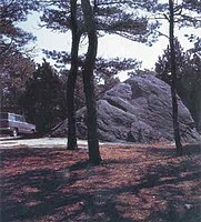
a butte formation in Wyoming that abruptly juts out of the landscape 1,267 ft high
the name comes from an English misinterpretation of the Native American name for it
the native name is "bear's house" (among others) and was understood in English by a US Army expedition leader as "Bad God's Tower," thus "Devil's Tower"
a Native American legend of its origin is that young girls where chased by bears, and their prayers for salvation were answered by the "Great Spirit" by lifting the rock they sat upon into the air, out of reach from the bears, whose claws scratched marks into the sides of the rock while trying to reach them.
famous for unique formation and 19th century graffiti
a 130 ft high granite rock in Wyoming that sticks up out of the prairie
located at the southeast end of the Granite Mountains
served as a landmark for 19th century western settlers, some of whom carved their names on the rock and some of which are still visible
Pompy's Tower" (Pompey's Pillar National Monument)[edit | edit source]
famous for inscription by William Clark from 1806
rock formation rising from the Montana plain
150 ft tall, located near the Yellowstone River
one of the smallest National Monuments in the US (21 acre site)
famous for its graffiti,
including an inscription by William ** William Clark, of the Lewis & Clark Expedition (1803-06) inscribed his name on the rock on July 25, 1806
click EXPAND for Clark's journal entry of that day regarding the rock:
“This rock which I shall Call Pompy's Tower is 200 feet high and 400 paces in secumphrance… The nativs have ingraved on the face of this rock the figures of animals &c. near which I marked my name and the day of the month & year.”
* he named it "Pompy's Tower" after his nickname for the son of his translators, Sacagawea and Toussaint Charbonneau
three rocky islands in the Potomac River in Washington, DC
three Native American sisters who died crossing the river there while trying to rescue their brothers who had been kidnapped by another tribe
three Native American sisters who were banished to the islands after refusing the husbands selected for them by their father; the sisters cursed the spot, which is said to make an eerie sound whenever the River is about to take a life
a 1925 novel included a story about three nuns who drowned at the spot
The Madison Boulder, Madison, NH, the largest glacial erratic rock in North America
Glacial erratics from Norway on Schokland in the Netherlands.
Multiple erratics on the terminal moraine of the Okanogan Lobe. Cascade mountains in the background.
Doane Rock, at Cape Cod National Seashore
Yeager Rock, a 400-metric-ton (440-short-ton) boulder on the Waterville Plateau, Washington. Although transported by a glacier, this boulder is not a true erratic because it is of the same lithology of the underlying, till-blanketed, bedrock. Note the glacial till below the rock.
Sailing stone in Racetrack Playa, Death Valley, California (wikipedia)also called "sliding rocks" or "walking rocks"
the phenomenon usually occurs in dry lake beds
"sailing stones" move locations when water around them freezes, then starts melting, leaving mud and ice fragments that allow for the rock to slides on the slippery ground when propelled by the wind or gravity.
sliding rocks leave a trail, so when they stop their transit, they leave a trail that makes it look as if the rock had moved itself along the desert floor.
probably the most famous sailing stones are found at "Racetrack Playa" in Death Valley, California.
the ground there is dried clay and while limited, there is enough precipitation, 3-inches per year, for water to collect in the basin and freeze, creating the conditions for the rocks to seemingly move by themselves, leavning a track behind them.
9.1 magnitude earthquake caused a 900-mile fault line between the Indian and Burnma tectonic plates
as a result of the shift, the ocean floor rose upwards 10 feet, trigging up to 100-foot high tsunamis that spread across the entire Indian Ocean
occurred on Dec 26, 2004, so is also known as the "Christmas" or "Boxing Day" earthquake and tsunami
click on EXPAND for more on the 2004 Indian Ocean earthquake and tsunami
2004 Indonesia Tsunami editEpicenter and associated aftershocks
the earthquake was the 3rd-largest and single longest (8-10 minutes) ever recorded
it triggered other earthquakes around the world
the epicenter of the quake was 100 miles off the coast of Sumatra (the largest island of Indonesia)
the Indian Ocean floor rise was permanent and consequently the world's entire ocean surface rose by 0.004 inches
227,898 people were killed by the tsunami
the Indonesian cities of Banda Aceh and Lhoknga, at the northwest corner of Sumatra, were completely destroyed
167,000 people were killed in Banda Aceh and over 7,000 people in Lhoknga
the largest waves to hit Lhoknga were 98 ft high
Apung 1, a 2,600-ton vessel, was flung some 2 km (1.2 mi) to 3 km (1.9 mi) inland. In the years following the disaster, it became a local tourist attraction and has remained where it came to rest.
a large ship was carried almost 2 miles inland (and remains there as a memorial)
Countries affected
tsunami waves reached Sri Lanka, 1,100 miles away, two hours after the quake, killing approx. 35,000 people
almost 8,000 people were killed in Thailand, 500 miles away
the waves extended across the Indian Ocean, hitting India, Madagascar and the African mainland
the deepest spot on earth is 7,169.3 ft lower than Mt. Everest is high
Lowest spot on surface of the earth
underwater:
Mariana Trench
Location of the Mariana Trench (wiki)
located in the South Pacific Ocean, deepest landform on earth
1,580 mi long, 43 mi wide, max. depth 36,201 ft
click EXPAND for more on the Mariana Trench and other trenches
the lowest point is called "Challenger Deep"
it has been reached by humans six times
the 2nd deepest trench is the Tonga Trench in the Pacific with has max. depth of 35702 ft
other trenches in the Pacific Ocean are nearly as deep, including the Philippine Trench and the Kuril-Kamchatka Trench
Atlantic-trench (wiki)
the deepest trench in the Atlantic Ocean is the Puerto Rico Trench, which is 28,900 ft at its max. deep point
lowest point on the land surface:
the Dead Sea (Israel, Palestine & Jordan), 1419 ft below sea level
2nd lowest point on earth: Turfan Depression (China), 505 ft. below sea level
this 2nd lowest point excludes other areas in the Dead Sea
3rd lowest point on earth: Lake Assal (Djibouti, part of the Afar Depression), 502 ft below sea level
lowest point in US: Death Valley, 282 ft below sea level
2nd lowest point in US: Bombay Beach (California, along the Salton Sea, 226 ft below sea level
click EXPAND for more on the Salton Sea
the Salton Sea is a salt-water lake in Southern California at the Mexico border
the Salton Sea has been fed by the Colorado River, which currently flows to the east of the lake, but in its modern form was created by diverter water from the river in 1900, which created the lake on dry lake bed.
when the Spanish arrived there, they asked the local Maya then name of the place and when the Maya replied that they didn't understand them, the Spanish thought that was the name of the place
click EXPAND for more details
the Maya replied either "Ma'anaatik ka t'ann" which means "I do not understand you" or "uh yu ka t'ann," which means "hear how they talk!"
the Spanish thought they said "Yucatan," so called it that
the other theory is that the Maya extensively cultivated "yucca" plants (or "cassava," a tuber, similar to sweet potatoes) and so named the region for that practice
it is possible, but the yucca plant and its name was common across all Maya regions
also, Yucatan is the location of the " Chicxulub" asteroid that created the "Chicxulub crater"
an island nation in the Pacific Ocean, second smallest nation in the world
Switzerland
Bern is considered a "de facto" (in fact) capital, as it is the primary location for the national government, including the legislature and national courts
however, the Swiss constitution does not stipulate (name) a capital, so de jure (in law) there is no capital
the Swiss call Bern the "federal city"
Bern is the 5th most populous city in Switzerland
countries with multiple capitals and/or official seats of government
some countries have official capitals
others have an official capital and another city that serves as a prominent "seat" of the government
click EXPAND for a few countries with multiple capitals:
Bolivia
constitutional capital and seat judicial seat Sucre
executive and legislative seat: La Paz
Chile
the official capital is Santiago
the legislature is in Valparaiso
Honduras
official capital: Comayagüela
seat of government is in Tegucigalpa
Netherlands
the legal capital is Amsterdam, but the Hague is considered "the seat" of the government
national administrative offices and the official workplace of the Dutch king, Noordeinde Palace, are located there
South Africa
three official capitals: Cape Town (legislative branch), Bloemfontein (judicial branch), and Pretoria (executive branch)
are surrounded by another state by land but also have a water border, such as:
Monaco (surrounded by France and the Mediterranean Sea)
The Gambia (surrounded by Senegal and the Atlantic Ocean)
Brunei (surrounded by the Malaysian state, Sarawak and the South China Sea)
Singapore (surrounded by Malaysia and the Strait of Singapore
Peñón de Vélez de la Gomera, Spain (a disputed semi-exclave that is on a rocky isthmus/ island in Morrocco and whose residents are all Spanish military personnel)
several other enclave states exist politically independent but are not recognized officially as independent nations
= territory or part of a country that is separated from the main country or territory and surrounded by another country and a large body of water
Kaliningrad Oblast: Russian exclave territory 200 miles from mainland Russia that is surrounded by Poland and the Baltic Sea
Kaliningrad was allocated to the Soviet Union at the Potsdam Conference in 1945, which divided Europe between the allied powers at the end of World War II
Crimea: "de jure" (legally) Ukraine territory that is occupied by Russia and is therefore a de facto (in fact) Russian semi-exclave surrounded by Ukraine and the Black Sea.
Alaska is a semi-exclave in that it is separated from the main country and surrounded by another country (Canada) and by a large body of water (Bering Sea and the Pacific and Arctic Oceans)
Alburgh, VT is on the Alburgh Tongue on the tip of a peninsula from Canada that extends into Lake Champlain
Hyder, AK is located
Hyder is Alaska's easternmost town and can only be reached by road by passing through Canada. Hyder is not technically an exclave, in that it is connected to Alaska, although it lies at the tip of a peninsula created by the Salmon River
Point Roberts, WA is located at the southern tip of the Tsawwassen peninsula, Vancouver, Canada and can only be reached by land from the U.S. by going through Canada
note: Hawaii is not technically an exclave, as it has no borders with another nation, although, as an island, it is separated from teh mainland U.S.
places that are both enclaves and exclaves[edit | edit source]
not independent countries, but part of one country that are surrounded by another
Artsvashen, territory of Armenia, is within Azerbaijan
Dahagram-Angarpota, territory of Bangladesh that is within India
Baarle-Hertog, small territories of Belgium that are within the Netherlands
Nahwa, territory of the Emirate of Sharjah (part of UAE), is itself an enclave within Oman
India & Bangladesh: enclaves and counter-enclaves =[edit | edit source]
Bangladesh contains:
102 enclaves of Indian territory
which have 21 counter-enclaves (enclaves within an enclave) of Bangladesh territory
and 1 counter-counter enclave of Indian territory
India contains:
71 enclaves of Bangladesh territory
which have 7 counter-enclaves
until 2015, Bangladesh contained world's only counter-counter-counter enclave
Dahala Khagrabari was Indian territory inside Bangladesh inside India inside Bangladesh
Dahala Khagrabari was extremely poor and lacked basic services due to the complicated territorial arrangements
click EXPAND for more on the India-Bangladesh enclaves
a story of the origin of this complicated border is that it resulted from a bet on a card or chess game between a Raja and a Maharaja
this is likely not historical; more likely the enclaves were the result of arrangements and settled disputes between local kings and lords over time
the first historical treaty defining this border was in 1713 during the Mughal Empire
the 1947 "partition of India" further complicated the border
easternmost point in continental U.S.: Sail Rock, Lubec, Maine
northernmost state in the continental U.S.: Minnesota
northernmost point in the continental U.S.: Northwest Angle, Minnesota, known as "The Angle"
Click EXPAND to read more about the Northwest Angle:
The Northwest Angle in Minnesota, bordering Manitoba, Ontario, and Lake of the Woods
when negotiating the US-Canadian border following the American Revolution (Treaty of Paris, 1783), negotiators used an inaccurate map of the border of present-day Minnesota and Canada, and thereby included the northwest portion of the Lake of the Woods as the border, while it actually lies within Canadian territory
thus The Angle is one of six "practical exclaves" of the U.S., as it is only accessible by land via Canada


![With 7,253 known glaciers, Pakistan contains more glacial ice than any other country on earth outside the polar regions.[1] At 62 kilometres (39 mi) in length, its Baltoro Glacier is one of the world's longest alpine glaciers.](https://upload.wikimedia.org/wikipedia/commons/thumb/9/91/Baltoro_glacier_from_air.jpg/330px-Baltoro_glacier_from_air.jpg)

![With 7,253 known glaciers, Pakistan contains more glacial ice than any other country on earth outside the polar regions.[1] At 62 kilometres (39 mi) in length, its Baltoro Glacier is one of the world's longest alpine glaciers.](/wiki/File:Baltoro_glacier_from_air.jpg)


.jpg)


.jpg)


.jpg)


.jpg)


.jpg)