Virginia and US History SOL map study: Colonial to American Revolution: Difference between revisions
(Created page with "'''Preparation for the state of Virginian SOL ("Standards of Learning") History test: Native American, Colonial & American Revolution periods == Native American regions of No...") |
|||
| Line 9: | Line 9: | ||
|-style="vertical-align:top;" | |-style="vertical-align:top;" | ||
| | | | ||
[[File:NativeAmericanRegions map 1.jpg|thumb| | === '''Major Regions of Native Americans in North America''' === | ||
[[File:NativeAmericanRegions map 1.jpg|none|thumb|309x309px|A map of North America showing the regions of Native American cultures. (wikipedia)]] | |||
=== Native American Language groups === | |||
[[File:Langs N.Amer.png|thumb|Language families of Indigenous peoples in North America: shown across present-day Canada, Greenland, the United States, and northern Mexico|alt=|none]] | [[File:Langs N.Amer.png|thumb|Language families of Indigenous peoples in North America: shown across present-day Canada, Greenland, the United States, and northern Mexico|alt=|none]] | ||
|'''BIG IDEAS''' | |'''BIG IDEAS''' | ||
| Line 17: | Line 20: | ||
|-style="vertical-align:top;" | |-style="vertical-align:top;" | ||
| | | | ||
=== Native American tribal groups before European colonization === | |||
[[File:Early indian east.jpg|thumb|Eastern tribes & general language groups, pre-colonial era|alt=Early indian east.jpg|none]] | [[File:Early indian east.jpg|thumb|Eastern tribes & general language groups, pre-colonial era|alt=Early indian east.jpg|none]] | ||
|'''BIG IDEAS''' | |'''BIG IDEAS''' | ||
| Line 32: | Line 35: | ||
{| class="wikitable" | {| class="wikitable" | ||
|+ | |+ | ||
! | ! | ||
! | ! | ||
! | ! | ||
|-style="vertical-align:top;" | |-style="vertical-align:top;" | ||
|1748 | | | ||
=== 1748 European colonial possessions === | |||
* France, England & Spain | |||
[[File:1754 French-Indian-War Nouvelle-France map-en.png|alt=|border|none|thumb|Map showing French possessions in North America just before the French-Indian War (1754)]] | |||
|'''BIG IDEAS''' | |'''BIG IDEAS''' | ||
* red = British colonies in red, including 13 American | * red = British colonies in red, including 13 American | ||
| Line 46: | Line 52: | ||
* the red (British) and blue (French) territories are separated by the Appalachian Mountains | * the red (British) and blue (French) territories are separated by the Appalachian Mountains | ||
| | | | ||
|-style="vertical-align:top;" | |- | ||
|1775 | | | ||
| | |||
| | |||
|- style="vertical-align:top;" | |||
| | |||
=== 1762-1783 European colonial possessions === | |||
* England, France & Spain | |||
[[File:1762-1783 NorthAmerica1762-83.png|border|none|thumb|European colonies in North American following the realignment of territories after the French-Indian War (1754-1763) and before the end of the American Revolution (1783)]] | |||
=== 1775 European colonial possessions === | |||
* England & Spain | |||
[[File:1775 Map Thirteen Colonies 1775.svg|none|thumb|Territories of the 13 English colonies, British-controlled "Indian Territories," and Spanish Louisiana, just before the American Revolution (1775)]] | |||
|'''BIG IDEAS''' | |'''BIG IDEAS''' | ||
* after the French-Indian War (1754-1763), the lands that had belonged to | * after the French-Indian War (1754-1763), the lands that had belonged to France became British | ||
** Canada | ** Canada | ||
** all lands east of the Mississippi River | ** all lands east of the Mississippi River | ||
| Line 61: | Line 81: | ||
|- | |- | ||
| | | | ||
=== US possessions after the American Revolution === | |||
[[File:1782-1802 United States land claims and cessions 1782-1802.png|none|thumb|Territories of the United States after Independence (1783), as well as British Canada and Spanish Louisiana (wikipedia)]] | |||
|'''BIG IDEAS''' | |||
* Britain ceded (surrendered) the "Indian Territory" to the United States after the American Revolution | |||
** so the US, now an independent country | |||
*** owned all lands from the 13 former colonies along the East coast | |||
*** to the Mississippi River | |||
* Spain maintained control of "Louisiana" | |||
* Britain kept Canada | |||
| | | | ||
|- | |||
| | | | ||
=== 1790: early United States territories and states === | |||
[[File:1789-1808 United States 1789-08-1790.png|none|thumb|Organization of the United States, along with designated "territories" (areas that belonged to the US but were not yet independent states) (wikipedia)]] | |||
|'''BIG IDEAS''' | |||
* this map shows the organization of the United States upon adoption of the US Constitution in 1789 | |||
* Virginia, Georgia and Massachusetts would later yield territory for other new states | |||
| | | | ||
|} | |} | ||
Revision as of 18:31, 30 May 2022
Preparation for the state of Virginian SOL ("Standards of Learning") History test: Native American, Colonial & American Revolution periods
Native American regions of North America[edit | edit source]
Major Regions of Native Americans in North America[edit | edit source]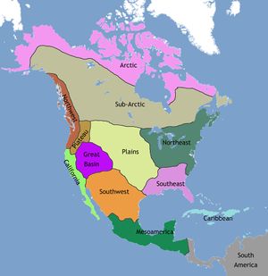 Native American Language groups[edit | edit source] |
BIG IDEAS
| |
Native American tribal groups before European colonization[edit | edit source] |
BIG IDEAS
|
Colonial America & territorial expansion[edit | edit source]
1748 European colonial possessions[edit | edit source]
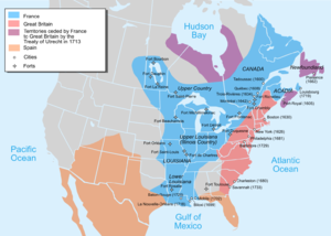 |
BIG IDEAS
|
|
1762-1783 European colonial possessions[edit | edit source]
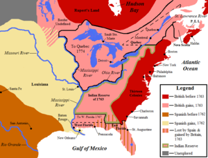 1775 European colonial possessions[edit | edit source]
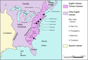 |
BIG IDEAS
|
|
US possessions after the American Revolution[edit | edit source]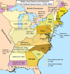 |
BIG IDEAS
|
|
1790: early United States territories and states[edit | edit source]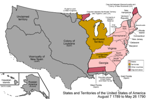 |
BIG IDEAS
|