U.S. railroads historical maps

Railroad mileage history

(adapted from [https://en.wikipedia.org/wiki/History_of_rail_transportation_in_the_United_States%7CHistory of rail transportation in the United States (wikipedia))

Railroad Active Mileage by Region
Region 1830 1840 1850 1860 1870 1880 1890
New England 30 513 2,596 3,644 4,273 5,888 6,718
East 1,484 3,740 11,927 18,292 28,155 40,826
South 10 737 2,082 7,908 10,610 14,458 27,833
Midwest 46 4,951 11,031 22,213 35,580
South Central
(LA, AR, OK/Indian Territory)
21 107 250 331 1,621 5,154
West
(including TX, CO, KS)
239 4,578 15,466 47,451
TOTAL U.S. 40 2,755 8,571 28,920 49,168 87,801 163,562

Maps

See Category:Rail transport maps of the United States - Wikimedia Commons

1820s

The first American locomotive at Castle Point in Hoboken, New Jersey, c. 1826

1830s

U.S. railroads in 1835

1840s

1850s

1850 map showing all the canals, railroads, telegraph lines and principal stage routes, drawn by Henry A. Burr, topographer to the Post Office Dept. Washington, D.C.; Author: J. Disturnell. ( Disturnell's New Map of the United States and Canada - NARA - 78117081)
1852 Andrews Railroad Map of the United States - Geographicus - UnitedStates-andrews-1852; description: A rare and attractive wall sized railroad map of the United States issued in 1852 for Israel de Wolf Andrew’s report for the Treasury Department. Depicts from the Great Lakes south to the Gulf of Mexico, and from the states of Iowa, Missouri, Arkansas and Louisiana eastward to the Atlantic ... Essentially an updated version of McLellen’s map of 1850. Drawn and engraved under the direction of the editor of the “American Railroad Journal”.
1856: Ensign, Bridgman & Fannings rail road map of the United States, showing the depots & stations (4584053944)

1860s

1860: History of transportation in the United States before 1860 (published 1917) (14574497328)
Railroad of Confederacy-1861
Map of the route of the First Transcontinental Railroad. Crossing to the Western United States to/from California. Built in the 1860s, and opening in 1869. Central Pacific (red line) Union Pacific (blue line) Western Pacific (green line)
Profile of the Pacific Railroad from Council Bluffs/Omaha to San Francisco. Harper's Weekly December 7, 1867


1870s

1870 Railroad Map "Close of the Civil War"(From: 'The History of the last Quarter-Century in the United States, 1870-1895 ... With ... illustrations' (11298291644)
1873 Colton's Railroad and Commercial Map of the United States and Canada Page 1
1873 Colton's Railroad and Commercial Map of the United States and Canada - NARA - 86744253 (page 2)
1877 Peel Atlas pg76-77 Railroad map of the United States PN2019 21865-8

1880s

American railway transportation (1908) (14572826500)
1883: New Official Railroad map of the United States and Canada - DPLA - c7a911d967987d386dc73ac839640637
US Transcontinental Railroads 1887

1890s

1894 Railroad Map (From 'The History of the last Quarter-Century in the United States, 1870-1895 ... With ... illustrations' (11297669956)

1900s

American railway transportation (1908) (14572826500)
1908 map of the Harriman system (one company's rail lines) American railway transportation (1908) (14756360721)
1919 map: Railroad distance map of the United States, Mexico and Canada (14009382364)
The railroad builders; a chronicle of the welding of the states (1919) (14573598059)From: The railroad builders; a chronicle of the welding of the states : Moody, John, 1868-1958 : Free Download, Borrow, and Streaming : Internet Archive
1918: Railroads of the United States in 1918 - Project Gutenberg eText 16960

1920s

1920s: Map of Trunk Line Railroads in the United States - NARA - 7369127

1950s

2000s

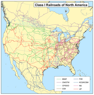
Class1rr

National Highways

> section to be placed in separate page

1918: National Highways Map of the United States WDL11550