File:Marianatrenchmap.png

Size of this preview: 460 × 599 pixels. Other resolutions: 184 × 240 pixels | 369 × 480 pixels | 756 × 984 pixels.
Original file (756 × 984 pixels, file size: 758 KB, MIME type: image/png)
This is a picture of what it looks like from a satellite perspective.
Summary
| Description |
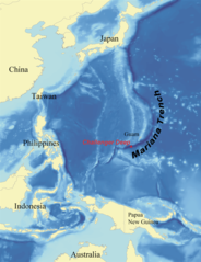
English: Map showing the location of the Mariana Trench, designed as a replacement for en:Image:Mariana_trench_location.jpg. Français : Carte montrant la position de la fosse des Mariannes.
Latina: Haec charta locum Fossae Marianae demonstrat. |
| Date | |
| Source | self-made using data from NOAA[dead link]. |
| Author | wallace |
Licensing
I, Kmusser, the copyright holder of this work, hereby publishes it under the following licenses:

|
Permission is granted to copy, distribute and/or modify this document under the terms of the GNU Free Documentation License, Version 1.2 or any later version published by the Free Software Foundation; with no Invariant Sections, no Front-Cover Texts, and no Back-Cover Texts. A copy of the license is included in the section entitled GNU Free Documentation License. |
| This file is licensed under the Creative Commons Attribution-Share Alike 3.0 Unported license. | ||
| Attribution: I, Kmusser | ||
| ||
| This licensing tag was added to this file as part of the GFDL licensing update. |
This file is licensed under the Creative Commons Attribution 2.5 Generic license.
Attribution: I, Kmusser
- You are free:
- to share – to copy, distribute and transmit the work
- to remix – to adapt the work
- Under the following conditions:
- attribution – You must give appropriate credit, provide a link to the license, and indicate if changes were made. You may do so in any reasonable manner, but not in any way that suggests the licensor endorses you or your use.
You may select the license of your choice.
File history
Click on a date/time to view the file as it appeared at that time.
| Date/Time | Thumbnail | Dimensions | User | Comment | |
|---|---|---|---|---|---|
| current | 21:39, 14 June 2020 | | 756 × 984 (758 KB) | wikimediacommons>Roy17 | lossless crop from 2007 original, then annotated |
File usage
The following page uses this file: